48,44Lei
Express deliveryTuesday, 10 Septemberif you order it in the next 17 hours and 14 minutes
+11,99 Leishipping cost - sent from Greece
Selected Store
Stock 8 pieces
Skroutz Buyers Protection
Set the delivery location to see products according to your choice.


Selected Store
Stock 8 pieces
Skroutz Buyers Protection


Teaching Aid Books


Teaching Aid Books


Teaching Aid Books


Teaching Aid Books

Teaching Aid Books


Prices are calculated for:Romania, Other Payment Options
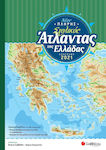
The Geo-Historical Atlas "From Prehistory to Byzantium" includes over 50 maps and diagrams of the most important periods in History: From the emergence of agriculture and ancient civilizations of the Mediterranean to the creation of cities. It continues with the ancient Greek world, classical Athens, the Persian wars, the civil strife of the Peloponnesian War, and the Alexandrian oecumene. It follows the dominance of the Romans and the triumph of Constantine the Great in the East, the evolution of the Western Roman state into smaller states, and concludes with the empire of New Rome up until the fall of Constantinople (1453). The text accompanying the maps, in addition to the historical overview, provides an interpretation of historical developments from the perspective of migrations and the need for the settlement of nomadic peoples in settlements and the further development of urban networks. Timelines of the eras and visual material enrich the edition, which aims to enhance and complement the teaching of history lessons.
Specifications are collected from official manufacturer websites. Please verify the specifications before proceeding with your final purchase. If you notice any problem you can report it here.
Simply amazing. I am truly excited. Both the authors and the publishing house deserve congratulations.
Verified purchase
 Technology
 Home & Garden
 Fashion
 Sports & Outdoors
 Health - Beauty
 Baby & Kid
 Auto - Moto
 Business - B2B
 Books
Books